weatheronline.co.uk
(Page 2 of 2)
 High temps continue further south while the north is cooler and wetter.
Good morning, Hot conditions continue today across central and southern
England into east Wales. Plenty of sunshine here and staying mainly
dry, though the risk of an isolated heavy shower cannot be completely
ruled out. Cooler and wetter further north as central and southern
Scotland and Northern Ireland will see outbreaks of rain, heavy and
potentially thundery in places. Northwest England as well as northwest
Wales will also see some patchy rain. Patchy rain affects northern
into central England including Wales overnight. The far south and
southeast will remain mainly dry. Further north, spells of rain, heavy
at times into western Scotland. Some scattered showers onto western
coasts of Ireland. Otherwise largely dry. Temperatures climbing into
the mid 30s for much of central and southern England and east Wales,
21 to 27C across northern England, west Wales and Ireland, 17 to 21C
thro
ugh Scotland. Have a great day. Alexi
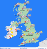
High temps continue further south while the north is cooler and wetter.
Good morning, Hot conditions continue today across central and southern
England into east Wales. Plenty of sunshine here and staying mainly
dry, though the risk of an isolated heavy shower cannot be completely
ruled out. Cooler and wetter further north as central and southern
Scotland and Northern Ireland will see outbreaks of rain, heavy and
potentially thundery in places. Northwest England as well as northwest
Wales will also see some patchy rain. Patchy rain affects northern
into central England including Wales overnight. The far south and
southeast will remain mainly dry. Further north, spells of rain, heavy
at times into western Scotland. Some scattered showers onto western
coasts of Ireland. Otherwise largely dry. Temperatures climbing into
the mid 30s for much of central and southern England and east Wales,
21 to 27C across northern England, west Wales and Ireland, 17 to 21C
thro
ugh Scotland. Have a great day. Alexi
------
back...
Main Menu
-----